The name of my site is the name of my system. Every place in and around Chicago exists at one specific time only. In this neighborhood, it is always October; in this town, it is always July.
In the map below, pink is summer, orange is autumn, blue is winter, and green is spring. Lighter shades are earlier in the season, darker colors are later. Just zoom and click anywhere in the shaded area to see what month or season is assigned:
Time flows from east to west across the map, so months and seasons run north and south in long, narrow strips, separated by major vertical streets. In other words, there is a formula by which longitude, or the distance from State Street, corresponds to a particular time of year. Three repetitions of the four seasons proceed in their proper sequence: from early summer in the Indiana Dunes, through the city proper (which experiences every season at least once), to late spring on the far bank of the Fox River. These twelve seasons add up to THREE YEARS IN CHICAGO. I'm always out walking to investigate them, and I made this site to share my pictures, so you too can experience my twisted alternate reality (or more accurately, my sub-set of reality).
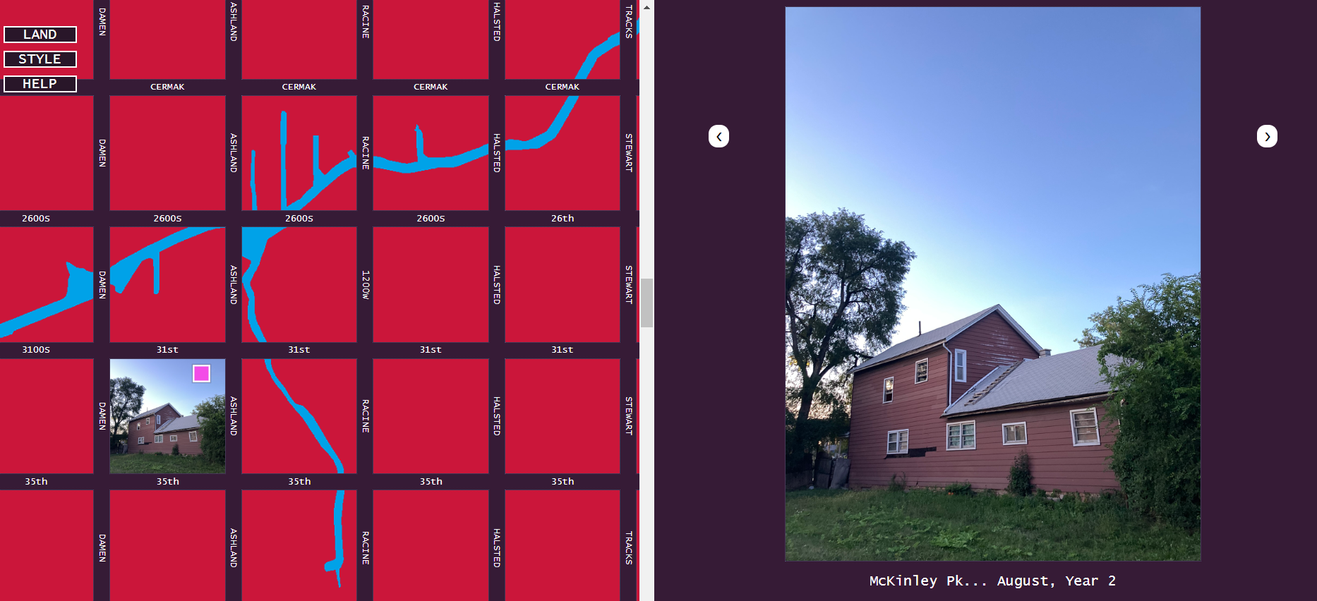
If so, I hope you'll come back on a larger one later, since my photo journal may be hard for you to view! (It uses advanced 1980s "frame" technology.) This is the main attraction of my site, containing about 27,000 of my seasonally-appropriate pictures from all over Chicagoland, carefully sorted by location. But you're also invited to continue reading down this page for further information about my system. And I sorted the best pictures into a series of mobile-friendly essays. You can start from the first one here.
First of all, here's an alternate version of the interactive map at the top of the page. Please click to enlarge, and you'll see some familiar streets along the coastline, along with their address numbers.
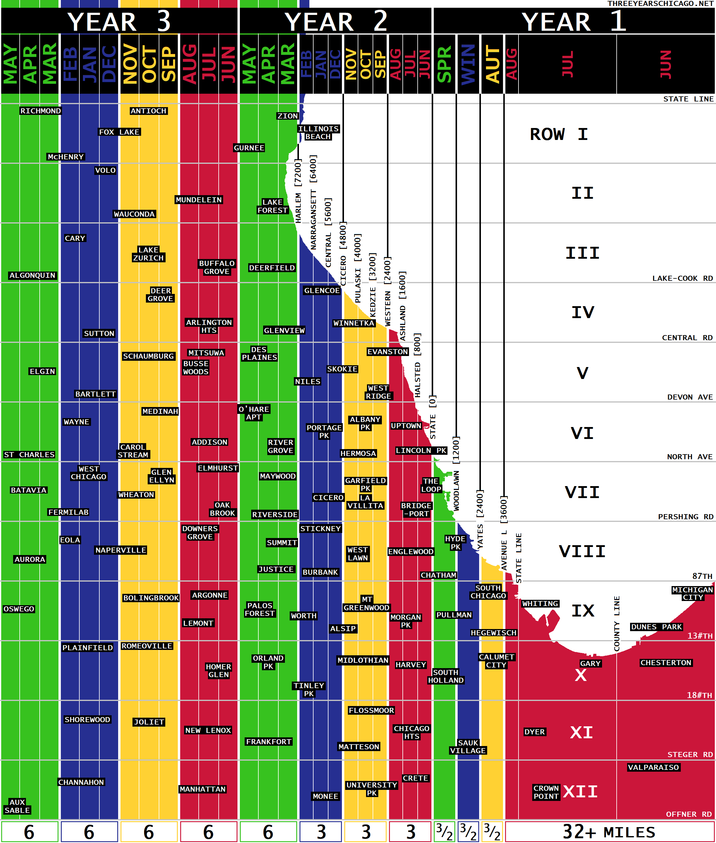
You'll notice that the width of one month is not constant across the map, but neither is it random. The first summer is aberrationally large, but the next three seasons are all one and a half miles wide, followed by three seasons of three miles each, and finally by five seasons of six miles. Generally speaking, the changes of season are more frequent in more densely populated areas, where moving just a short distance (neighborhood to neighborhood) can involve drastic changes of scenery. You could say there's more history per square mile in these areas. Conversely, in the west and east outskirts of the city, population density goes down and the change of seasons is a lot slower. One must move greater distances (town to town) to observe an equivalent change.
It is also in the central city that important vertical streets like Pulaski and Harlem serve as convenient boundaries between months and seasons. In fact you can easily determine the season from an address (for instance, 2727 West Any Street is September, Year 2, and all the buildings on Jeffery Blvd are in Winter, Year 1). Towards the east and west edges of the map, however, the seasonal boundaries may exist only in imaginary survey lines: invisible to the untrained eye, unnamed, and unnumbered.
| MONTH/SEASON | YEAR | RUNS WEST FROM... | ...TO... | WIDTH | |
|---|---|---|---|---|---|
| June | 1 | Downtown Michigan City | Lake-Porter County Line | 16+ miles | |
| July | Lake-Porter County Line | Illinois State Line | 16 miles | ||
| August | Illinois State Line | Avenue L [3600E] | <1 mile | ||
| Autumn * | Avenue L [3600E] | Yates [2400E] | 1.5 miles each | ||
| Winter * | Yates [2400E] | Woodlawn [1200E] | |||
| Spring * | Woodlawn [1200E] | State [0EW] | |||
| June | 2 | State [0EW] | Halsted [800W] | 1 mile each | |
| July | Halsted [800W] | Ashland [1600W] | |||
| August | Ashland [1600W] | Western [2400W] | |||
| September | Western [2400W] | Kedzie [3200W] | |||
| October | Kedzie [3200W] | Pulaski [4000W] | |||
| November | Pulaski [4000W] | Cicero [4800W] | |||
| December | Cicero [4800W] | Central [5600W] | |||
| January | Central [5600W] | Narragansett [6400W] | |||
| February | Narragansett [6400W] | Harlem [7200W] | |||
| March | Harlem [7200W] | East River [8800W] | 2 miles each | ||
| April | East River [8800W] | Mannheim [10400W] | |||
| May | Mannheim [10400W] | Cook-DuPage County Line [12000W] | |||
| Summer † | 3 | Cook-DuPage County Line | York-Milton Township Line | 6 miles each | |
| Autumn † | York-Milton Township Line | Milton-Winfield Township Line | |||
| Winter † | Milton-Winfield Township Line | Winfield-Batavia Township Line | |||
| Spring † | Winfield-Batavia Township Line | Batavia-Blackberry Township Line |
* Autumn, Winter, and Spring of Year 1 are not divided into three months. The season is the most specific property of these areas.
† The four seasons of Year 3 are all fully divisible into three months of two miles apiece, but in the western suburbs, one rarely finds a named or numbered road running along the month or season boundaries, so I have simplified the table accordingly.
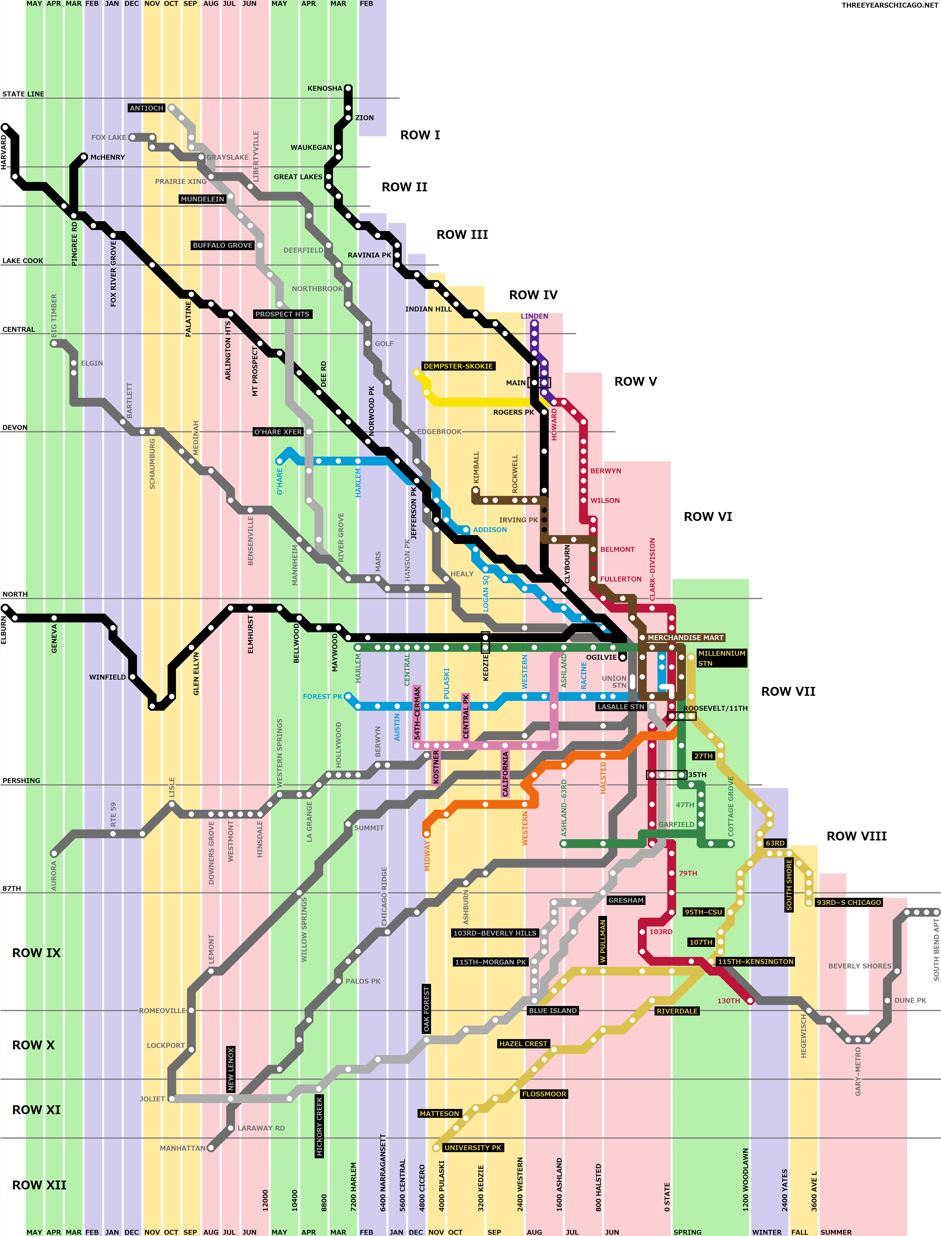
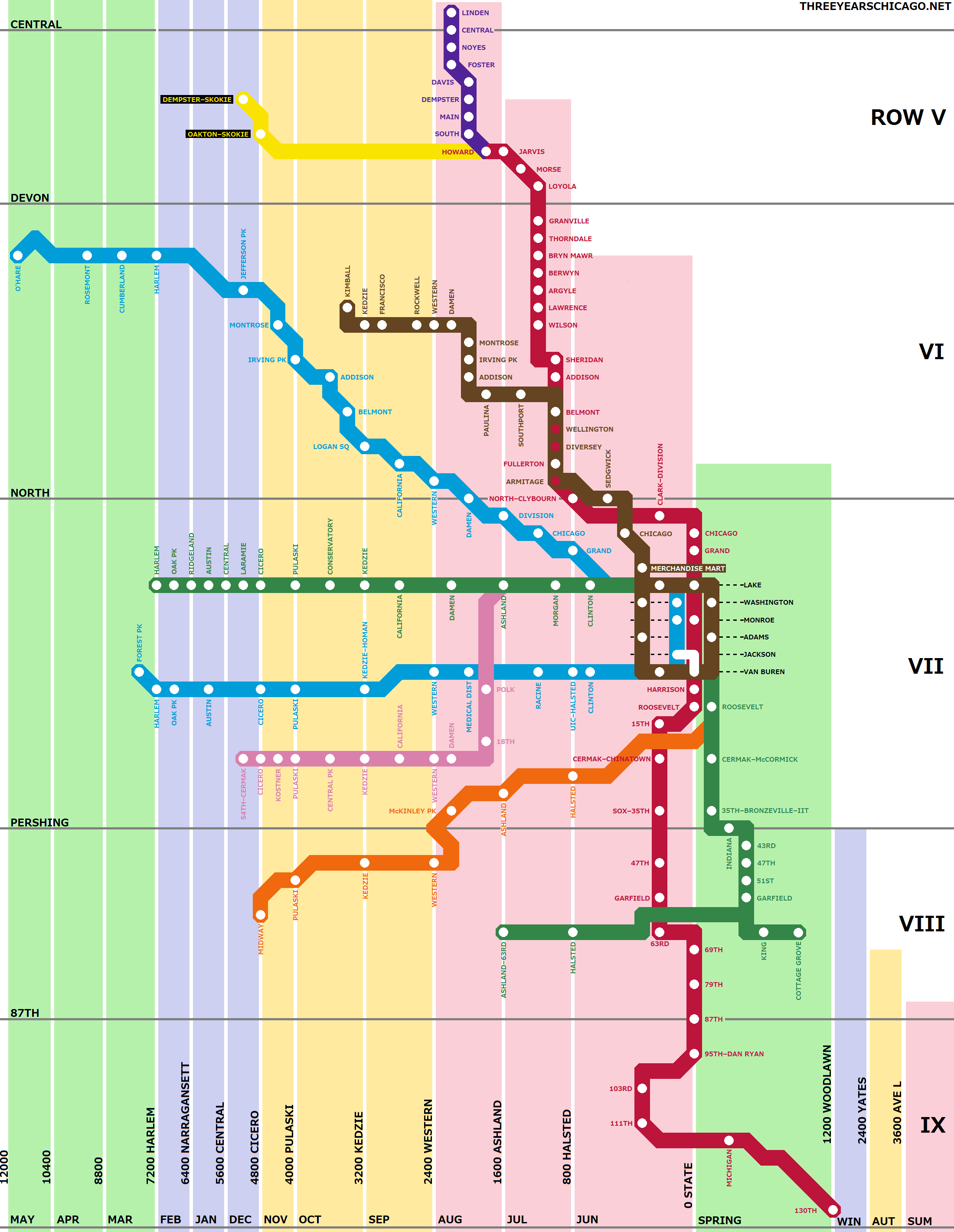
I designed this map to preserve horizontal and vertical relationships in the system. That is, a station on my map which appears to be further north/south/east/west than another station really is so. If you want to print this map out, you can print this full list of stations on the back side!
I already provided a link above to my photo journal, where I've collected all the (decent) pictures from my travels throughout the Three Years. My pictures are not only seasonally-appropriate to their location; I also sort them into small buckets by location, so it approaches a curated alternative to Google Street View. The big problem with the journal is that it's not done yet! I used to like long, linear walks from station to station, but at the moment I much prefer spiraling around within a small area like I was stuck in a labyrinth or something. And so each month I take a lot of pictures in a few neighborhoods, rather than a few pictures in a lot of neighborhoods. At my current pace, I'll "finish" the map in 2028, when a lot of interesting buildings of today will have been demolished. So if the areas you're interested in are grayed out for the time being -- I'm sorry about it too!
Neighborhoods aren't assigned randomly to their months and seasons in my system. To the contrary, it was my hope that the season in which they appear helps you see them at their best, and to interpret them in the context of larger Chicago history. The "real" Uptown is the lakeside summer retreat of the Jazz Age, with its crowded beaches and theaters; Uptown in winter is clearly less essential. Joliet is emblematic of the crumbling, rusty, melancholy autumn of American industry. You'll find cryogenically-frozen pockets of pre-integration Chicago in neighborhoods like Jefferson Park and Clearing. And the key feature of the Des Plaines river is how it floods the northwest side every spring with the thaw.
When I finish my exploration, I'd like very much to write a book which treats the entire city in this vein. I'll begin at Summer 1 and proceed through Spring 3, giving a general description of themes for each season, and then discussing the specific places that illustrate them. I have prepared a rough outline for each of the twelve to start getting my thoughts in order on this subject, but it's not worth sharing just yet. What I do have, as I mentioned towards the top of the page, is a photo essay for each season that contains my best shots. Click here to begin from Summer Year 1, or you can navigate to the twelve individual pages using the multicolored buttons at the bottom of every page. All the pictures you see in these essays are also be available in the photo journal itself -- somewhere!
Everyone knows that Chicago has a regular grid plan of horizontal and vertical streets. Some residents have picked up on more detailed facts, like 800 address numbers being equal to a mile. But most people, I think, are not aware of how interesting this topic really is, and my system will make a lot more sense to those who have explored it further. So I've also prepared an introduction to Chicago geography for those who are curious.
The geography page introduces two large data tables, which are roughly equivalent to Periodic Tables of Chicago. One is an INDEX TO PLACES AND NEIGHBORHOODS in the region covered by my system, including their seasonal identities. You can quickly find your own neighborhood on this list and see where it exists in time. The other table is an incomplete but hopefully useful GUIDE TO CHICAGO STREETS, again emphasizing the seasonal qualities of the vertical streets (which exist at one point in time), but also naming the important horizontal streets (which cut across the seasons and have no identity as such).
Whether or not you believe in my system, you will find it very helpful as a mnenomic if you wish to fix the geography of Chicago in your memory. In fact, I have turned these tables into Anki flashcards for that very purpose, and I am happy to share them on request.
I learned how to spend all day walking across Chicago from a group called, believe it or not, Walking Across Chicago. Every walk is different but you'll always meet some great people there!
I don't have a car or a driver's license, and my exploration relies mostly on the holy trinity of CTA, Metra, and Pace. Chicago-L.org and ChicagoRailfan.com are invaluable resources for transit information and history. One quickly realizes that our present system is a ghostly shadow of what it once was and still could be. On that note, Streetsblog is a good place for screaming into the void.
Searching for benchmarks planted by the National Geographic Survey is a very interesting pastime which I am always meaning to get into.
The activity of city walking has a long and somewhat contentious history. Nobody likes a "slummer," who treats rough neighborhoods like human zoos full of exciting and desperate characters, or a "flaneur," whose ability to walk aimlessly for pleasure suggests that he must not work very hard for a living. Groups like the psychogeographers and the Situationists have periodically claimed to be the inventors of something as natural as taking a walk for pleasure, thus putting a rather pretentious stink on what is actually one of the simplest imaginable recreations. The way I see it, nothing could be healthier than innocent curiosity, but in this world of dust, it does not follow that the free exercise of curiosity is always ethical or advisable. Matt Green's website, aptly titled I'm Just Walkin', is probably the gold standard in virtuous urban walking, drifting like a happy cloud above a vomitous landscape of "ruins porn" and "wanderlust"-afflicted bloggers. The author is all but reduced to a floating eyeball, and the personality is expressed only in the decision of what to photograph, what to mention and omit. The walking takes on a distinct obsessive-compulsory character; to some extent, the privilege of a white man to move freely through the city becomes a laborious obligation. It is far from a joyless, grinding, task, but neither is it a frivolous game. Effort expended is never proof of accomplishment, but it is still a strong recommendation. There is something very nice about an undertaking which can be explained in ten words and takes ten years to complete -- like walking every block in New York City, taking it for granted that whatever is found was worth finding. My project does not begin to live up to these standards, but I have squared up against them as a guidepost. I also adore the walky-thinky genre that stretches from Basho to Sebald, never mind the thousand dullards that exist for every one who gets it right. And there are yet walkers who go a step further towards enlightenment: they do not document their wanderings in any form. In this connection, RIP Joseph Kromelis, the true-legendary "walking man" of Chicago.
My number one book in Chicago studies is Street Signs Chicago, by Bowden and Kreinberg. It's hard to describe, but this series of anecdotes loosely centered around Pilsen in the 80s brilliantly gets to the heart of the matter and shows how all the talk of a "City of Neighborhoods" is something of a cardboard cutout propped up to hide the reality of a place where basic human needs go unmet day after day after day. Runner-up, As Others See Chicago, ed. Bessie Pierce. It seems that most intelligent people of the nineteenth century felt compelled to come over and inspect Chicago just a little bit and then leave forever, whether they enjoyed the visit or not. Again we come to understand that Chicago was not really placed on Earth to be lived in.
I've lived on the South Side since I was eighteen -- "as soon as I could," quoth Mayor Cermak. For contact info and my other projects, please see my personal site!

| 3 | 3 | 3 | 3 | 2 | 2 | 2 | 2 | 1 | 1 | 1 | 1 |